
Surf and sand are not the only ways to experience Hawai‘i. Hiking is an excellent way for newcomers and locals alike to get to know O‘ahu. Sandwiched between the mountains and the sea, Honolulu alone has dozens of trails ready for exploring.
If you want to start off with an experienced guide, the Leisure Center has several group hikes planned for the fall semester. Assistant Director of Recreation Services Andy Johnson encouraged students to join in, saying, “Hiking gets you off the beaten track and into nature.”
But for independent spirits who want to strike out on their own, there are plenty of resources online and in hiking books that can be used to plan trips.
Just follow the recommended safety tips and take a few of your friends. The options are near endless.
David Chatsuthiphan, a photographer who documents his hikes on UnrealHawaii.com, gave this piece of advice, “If you’re new to hiking, the best place to start exploring is the area between ‘Āina Haina and Hawai‘i Kai. … Each of those ridges have novice-friendly hikes with amazing views at the end. It will get you hooked.”
On the other hand, O‘ahu trails and access specialist Aaron Lowe pointed out that “close to UH you have the entire Honolulu Mauka Trail system.”
To get you started, Ka Leo has compiled a list of trails based on web research and recommendations from Johnson, Chatsuthiphan and Lowe.
In the Neighborhood:
Mānoa Falls
0.8 miles, easy
A short, easy walk, Mānoa Falls is doable for even the meekest of beginners. It ends at a waterfall that is scenic but not suitable for swimming, as landslides have occurred. To the left of the viewing area is ‘Aihualama Trail, which continues up the ridge but is not recommended for beginners.
Makiki Valley Loop Trail and the
Honolulu Mauka Trail System
0.7 miles, 1.1 miles and 0.7 miles, consisting of easy, medium and difficult components
In nearby Makiki, just a short walk toward the mountains on Makiki Street and then Makiki Heights Drive, you’ll find the entrance to the Makiki Valley Loop Trail. This actually consists of three different trails called Maunalaha, Makiki Valley Trail and Kanealole. Doing the loop is pleasant in either direction and takes one to two hours, depending on how fast you go and whether you stop to read the signs and displays about the Makiki Valley watershed. But branching off from the loop is a web that connects to other trails in Mānoa and Nu‘uanu. If you download a map from Nā Ala Hele and research beforehand, the Honolulu Mauka Trail System has many quality hiking experiences to offer.
Ko‘olau ridges:
Wa‘ahila Ridge
2.4 miles, medium
Located at the top of St. Louis Drive, this hike is a work-out. It has great views of Mānoa Valley to the left and Pālolo Valley to the right, as well as of the Ko‘olau mountains and Honolulu. At the end you’ll encounter Kolowalu Trail, also known as Mt. Olympus, which Nā Ala Hele advises you do not continue on, as it is a restricted watershed area.
Lanipo
3.7 miles, medium
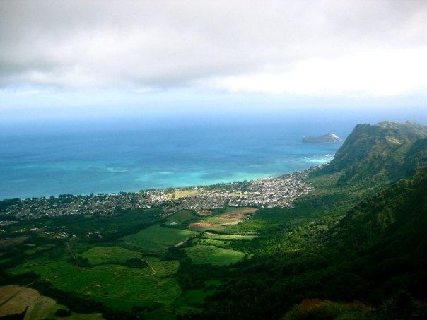
A round trip of about seven miles, Lanipō can be grueling if it’s hot out. But like the other ridge trails featured, it offers beautiful views as a reward. Throughout this hike you get panoramic views of the Ko‘olau Mountain Range and can see Ka‘au crater and its waterfall, Pālolo Valley, downtown Honolulu, the entire windward coast, and even the Wai‘anae Range in the distance.
Hawai‘i Loa Ridge
3.5 miles, medium
This hike starts at the top of a gated community, also known as Hawai‘i Loa, but is open to the public. Make sure someone in the car has a Hawai‘i state ID, tell the guard that you’re there to hike, and he’ll let you in. Make sure you have water and snacks, as this trail goes through hilly terrain to the top of the Ko‘olau range. The view of the Windward side is awesome, but the return trip makes for a four or five-hour round trip.
Kuli‘ou‘ou Ridge
2.5 miles, difficult
With beautiful, almost 360-degree views of the island below and interesting changes in terrain on the way up and down, Kuli‘ou‘ou Ridge is another excellent trail on the eastern side of O‘ahu. But watch out, the further up you go the less-used the trail is, and some spots can be difficult for the inexperienced.
Windward side:
Maunawili Falls
1.25 miles, easy
An easy but often muddy hike, the trail to Maunawili Falls is a fun and casual experience. Be prepared to get wet, as the trail crosses over streams several times and ends at a waterfall with a small pool in which you can swim. Also, pay attention to where you’re going, as there are a number of divergences on the trail and it’s possible to get turned around.
Olomana
2.5 miles, medium/difficult
Climbing Mt. Olomana is fun and the view is rewarding. The first two-thirds of the trail to the first peak are tiring and not super exciting, but after that come a series of steep climbs that are fun and sometimes a little scary. Use the ropes on the trail and negotiate the tough parts with the help of your friends. The view at the top of the first peak is truly amazing on a clear day. The trail continues on from there to the second and third peaks, but these are less worn and more dangerous. Last April, a hiker fell 150 feet and died. The second and third peaks are doable only for those who are cautious and confident in their abilities.
Special interest:
Lanikai Bunkers aka Pillboxes
1 mile, easy
Located on the Windward side, Lanikai Bunkers is a short but steep and sunny trail that leads to great views and the remnants of military fortifications from World War II.
Makapu‘u Tide pools
1 mile, medium
Branching off the trail to the Makapu‘u Lighthouse (which is paved and quite easy) is a lesser known and more arduous trail that leads down to a group of picturesque tide pools which are excellent for swimming and very photo-worthy.
Ka‘ena Point
2.7 miles, easy
Ka‘ena point can be accessed from Mokulē‘ia on the North Shore or from Wai‘anae to the west. For UH Mānoa students, the drive out may be the most daunting part, but if you can organize transportation it is well worth it. The westernmost point on the island, Ka‘ena point is the jumping-off place for souls going into the afterlife, and watching the currents from the north and west crash into each other, you can definitely feel the mana of this place.
Online resources:
O‘ahu offers many more trails than these, especially if you have access to a car and can expand your range up the Windward side toward the North Shore, or west to the Wai‘anae range. For more information on these and other trails (including driving and bus directions), visit the links below and do your own web searching.
Nā Ala Hele
www.hawaiitrails.ehawaii.gov
Unreal Hawaii
www.unrealhawaii.com/hikes
Island Trails
www.kaleolancaster.blogspot.com
Hawai‘i Trail and Mountain Club
www.htmclub.org
Important Safety Tips
•Bring water and snacks.
•Make sure you have proper footwear – that means hiking shoes or trail runners – to avoid slipping.
•Know your physical limits.
•Let someone know where you’re going and when to expect you back.
•Be aware of how long the hike is and your starting time, so you don’t get caught in the dark.
•Check the weather, beforehand, particularly for flash flood warnings.
•Never spend any time in or under a waterfall, because rock slides do occur.
•Be aware of leptospirosis; don’t drink water from
streams and if you have any cuts or open wounds, don’t go in the water.
•Be respectful of the homes and residential areas you may be parking in or walking through on your way to trails.
•Stick to “improved” trails, which are maintained for public use.
Leisure Center Hikes for Fall 2011
Aug. 19 Mānoa Falls
Aug. 20 Maunawili Falls
Sept. 5 Makapu‘u tidepools
Oct. 10 Olomana
Nov. 7 Lanikai Bunkers
Nov. 27 Ka‘ena Point